
Mount Rinjani Second Summit Trek (3126m) 2 Days 1 Night

TREK OVERVIEW
The Rinjani Second Summit also known as Mount Sangkareang (3,126 m) is a stunning alternative to the crowded main summit of Mount Rinjani. This unique route begins from Senaru Village, offering a spectacular journey through rainforests, steep volcanic trails, and wide savanna slopes, culminating in a sunrise hike to a quiet summit with sweeping views of Lombok’s coastline and volcanic ridgelines.
Officially opened in 2022, this route is perfect for those looking for a 2-day, 1-night trek with high adventure and low foot traffic.
TREK SUMMARY

-
Duration 2 days
-
Difficulty Level: Moderate to Difficult
-
Total Distance: 20,8 Km
-
Max Altitude: 3,126 meters (Mount Sangkareang – Second Summit)
-
Temperature: Daytime 26-34 ͦ C Nighttime 6-8 ͦ C
-
Starting Point: Senaru Village (North Lombok)
-
Season April-December
TREKKING HIGHLIGHTS
- Start your journey from Senaru Village, the historic gateway to Mount Rinjani
- Camp at the Crater Rim Senaru (2,641m) with incredible views of Segara Anak Lake and Mount Barujari volcano
- Hike in the dark to Rinjani Second Summit (3,126m) for a golden sunrise
- A less-traveled alternative to the crowded main summit route
- Suitable for beginner to intermediate trekkers in good physical condition
DETAILED ITINERARY
Day 1: Senaru Village (601m) – Crater Rim Senaru (2,641m)
Distance: 7.9 km
Difficulty Level: Moderate
Highest point: 2,641 m ( Senaru crater rim)
Height gain: +2,000 m
Walking Duration: 6.5 hours ascent to reach the crater rim
At 7:30 Am, and after having a breakfast at your hostel, the driver will pick you up and you will head to the entrance of the National Park Senaru.
Entrance to Position 1: The path from the entrance to Pos 1 is mainly flat and jungle. 1 km. It takes you 40 minutes to reach position 1.
From position 1 to position 2: 2.7 km, the treks begin to get more steep. More roots of the trees appear on the trail. It takes you 2 hours to reach position 2. After reaching Pos 2, you will make it to the stop for lunch. Amidst rainforest, and you will be surrounded by playful monkeys. The break takes 40 minutes for lunch, and you will continue to the next position.
From position 2 to position 3: there are 2.4 km, Gradually, the path begins to change after Pos 2, it is less trees and more grass. It takes you 1.5 hours to reach position 3. Stop at Pos 3 to take a little break before getting off to position 4.
From position 3 to position 4: 1.5 km, the path technical terrain with lots of big steps, and steep. It is slippery part with soft and loose earth. It takes you 40 minutes to reach position 4.
From position 4 to the Crater Rim: there are 300 m, the most challenging part, with rocky ascent path, it takes you 20 minutes to reach the Rim.
The Rim
Once you made it to the crater rim, you will see the huge crater filled with a lake and its special blue water surrounding the inner baby volcano was incredibly unique and picturesque. The peaks around it are massive, and you will be able to see Gilis Island in horizon and an epic sunset.
Day 2: Crater Rim – Second Summit (3,126m) – Return to Senaru
Distance: 2.5 km
Difficulty: Moderate to Challeaging
Highest point: 3,126 m (Mount Sangkarean/ Rinjani Second Summit)
Height gain: +485 m/-485 m
Walk duration: 2.5 hours
Night hike to Mount Rinjani Second Summit (3126 m)
Wake up 03:30 AM
Have a Light Snack & Night Hike to Second Summit With headlamps on, begin your climb to Mount Sangkareang (Second Summit). The 2 km trail is steep, with some rocky and overgrown sections challenging but rewarding.
Reaching Mount Rinjani Second Summit
05:30 AM – Sunrise at Rinjani Second Summit (3,126m)
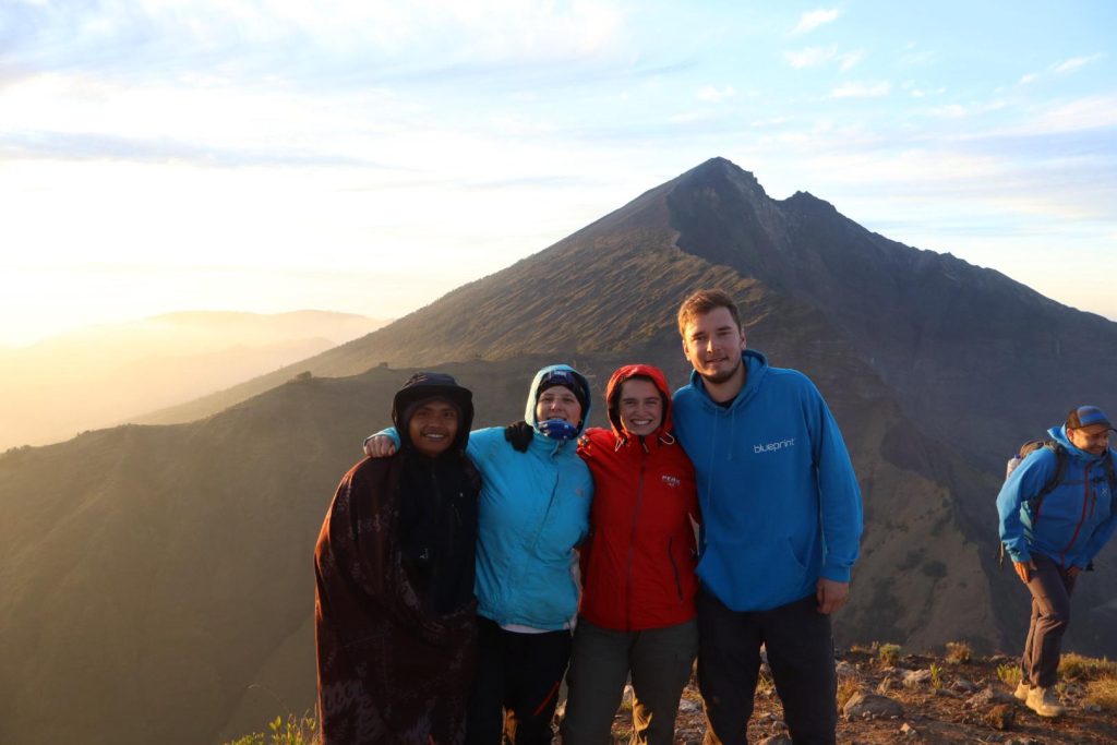
Reach the peak just in time for sunrise. From here, you’ll see Lombok’s northern coast, the Gili Islands, and the mighty main Rinjani summit glowing in the distance. While the lake isn’t visible from this point, the panorama is nothing short of majestic. 07:00 AM – Return to Camp & Breakfast
Descend back to Crater Rim for a hearty breakfast and some rest.
Senaru crater rim to Mount Rinjani National Park Office (Senaru)
Distance: 7.9 km
Difficulty Level: Easy
Highest point: 2,641m (Senaru crater rim)
Height gain: -2,000 m
Walking Duration: 5 hours descent to reach the departure village.
The way back
From Senaru Crater Rim to Senaru Village (601 m): after having breakfast begin descending to Senaru Village, 5 hours walking down with the same route. Going down slightly easier, you will be slipping and sliding on the loose earth from the rim to Position 4 and 3. After position 3 you will back in the jungle and enjoy the breeze which make hike down pleasant. After about 4 hours of going down, you will make it to the stop for lunch at position 1. After having lunch continue walking down to the beginning or the entrance for 25 minutes. The driver will pick you up and you will head to our office. The trek finish, pick the rest of your luggage, change the car and drop off to your next destination.
🏆 Recommended by World Travelers

Package Price Options
Premier Package
The Premier Service is our highest-level Mount Rinjani experience, thoughtfully designed for guests who want the very best, from the night before the trek to the final step on the trail.
With Premier, you’ll enjoy:
- Luxury pre-hike accommodation, carefully selected for comfort, atmosphere, and exclusivity
- Top-tier camping equipment, ensuring maximum comfort throughout your mountain stay
- Private service and personal attention, creating a seamless and worry-free journey
This service is ideal for travelers who wish to arrive on the mountain fully relaxed, well-rested, and confident, without compromising comfort at any stage of their Rinjani adventure.
View DetailsPremium Package
The Premium Service is ideal for guests who prioritize comfort on the mountain rather than luxury accommodation before the hike.
With Premium, you’ll enjoy:
- The same high-quality camping equipment and sleeping comfort as our Premier Service
- Carefully selected standard or mid-range pre-hike accommodation for a restful start
- Excellent value, offering a truly premium trekking experience without luxury hotel pricing
This option is perfect for travelers who prefer to invest in camping comfort and overall trekking quality, while keeping pre-hike accommodation practical and comfortable.
View DetailsDeluxe Package
A private Mount Rinjani trekking experience offering comfort, privacy, and excellent value. Enjoy a mid-range pre-hike accommodation (same category as Premium Service), comfortable camping equipment with a 4 cm sleeping pad, and the support of a dedicated private guide and porter team.
Perfect for active trekkers who want a well-organized, comfortable trek without luxury extras.
View DetailsStandard Package
A shared group trekking experience offering great value without compromising safety or comfort. Trek in a small group (max 6 guests) with reliable camping equipment, private tents, and the same nutritious meals as our Deluxe Package.
Enjoy a private room at Amazing Rinjani Villa before the hike, then share transportation with fellow trekkers to keep costs affordable.
🧍♀️ Solo Traveler Information
Traveling alone? No problem.
Solo trekkers are welcome to join our scheduled group departures and enjoy the full Mount Rinjani experience
This option is ideal for backpackers, digital nomads, and independent travelers who want a safe, social, and well-organized trek
View DetailsGOOD THINGS TO KNOW
BEFORE YOU GO
Is the Mount Rinjani Trek Right for Me?
Mount Rinjani trekking is suitable for travelers with good physical fitness and a sense of adventure. The terrain includes steep climbs, rocky paths, and long walking hours. While no technical climbing skills are required, prior hiking experience is highly recommended—especially for multi-day treks. If you enjoy nature, challenge, and breathtaking scenery, Rinjani is an unforgettable experience
How Many Days Should I Acclimate in Lombok Before the Trek?
We recommend spending at least 1–2 days in Lombok before your trek. This helps your body adjust to the climate, recover from long flights, and prepare physically for altitude and exertion. Staying hydrated, resting well, and avoiding alcohol before the trek will greatly improve your trekking experience.
Is There a Briefing Before the Trek?
Yes. All guests receive a full trekking briefing before departure. This includes:
- Route explanation & daily itinerary
- Safety procedures & trail conditions
- Equipment check
- Weather updates
- Q&A session
This ensures you are well-prepared, informed, and confident before starting the trek.
When Is the Balance Payment Made?
The remaining balance payment is usually made during the pre-trek briefing or meeting point before departure. We accept cash, card or tranfer and will inform you in advance about the exact payment method, so there are no surprises.
Can I Store My Luggage During the Trek?
Yes, absolutely. You may safely store extra luggage at the pre-hike accommodation luggage storage or our office while you are trekking Mount Rinjani. We recommend bringing only essential items in your daypack.
Do You Provide Pick-Up & Drop-Off Service?
Yes. We offer hotel pick-up and drop-off from major areas in Lombok such as:
Senggigi
Mataram
Bangsal Harbour
Kuta
Tetebatu
Please confirm your accommodation details in advance so we can arrange smooth transportation.
What Should I Know About Joining a Group Trek?
Group tours bring together travelers of different ages, fitness levels, and hiking experience. By joining a group trek, you acknowledge that:
- Some participants may hike faster or slower
- Everyone is free to walk at their own comfortable pace
- Guides ensure safety and fair pacing for all
Our professional guides are trained to manage group dynamics while maintaining safety and enjoyment for every participant.
Can the Trek Itinerary Be Modified During the Trek?
In some cases, the group may request changes due to weather, fitness, or trail conditions. Any modification will be carefully evaluated by the guide, who will consult all participants before making a final decision. The guide’s decision is always based on safety, park regulations, and group consensus.
Is Mount Rinjani Safe to Trek?
Mount Rinjani is safe when trekked with a licensed guide, proper equipment, and realistic expectations. We strictly follow national park regulations, monitor weather conditions, and prioritize guest safety at all times.
Is There Mobile Signal on the Mountain?
Mobile signal is available in a certain part on Mount Rinjani. This is a chance to fully disconnect and enjoy nature.
What If the Weather Is Bad?
Weather conditions are monitored closely. If trekking is unsafe due to heavy rain, strong winds, or park closure, we will offer rescheduling or alternative options in line with safety regulations.
Can I Rent Trekking Equipment From You?
Yes. We provide equipment rental for your convenience, including:
- Trekking poles
- Windbreaker jacket
- Long trekking pants
- Headlamp
- Handgloves
- Beanie
Rental prices are affordable and confirmed before the trek. Please let us know your size and equipment needs in advance so we can prepare everything for you.
Do Porters Carry My Personal Luggage or Backpack?
For safety reasons:
Porters carry shared camping equipment, food, and logistics
Guests are required to carry a small day backpack with personal items such as water, camera, jacket, and snacks
If you prefer not to carry your own backpack, an extra porter can be arranged upon request.
Do I Need to Bring My Own Drinking Water?
No. Drinking water is provided during the trek. However you carry your Drinking Water
What Time Will the Tour End on Day 2 or Final Day?
For 2-day and 3-day treks, the tour usually ends between 2:00 PM – 5:00 PM, depending on:
Trekking pace
Weather conditions
Route taken
Your guide will keep you informed throughout the trek.
I Am Vegetarian — Can You Provide Vegetarian Meals?
Yes, absolutely. We are happy to provide vegetarian meals during the trek. Please inform us in advance if you have:
Vegetarian or vegan preferences
Food allergies or dietary restrictions
Our trekking cooks are experienced in preparing nutritious meals for all guests.
After the Trek, Can I Continue to Gili Islands?
Yes, it is possible. If your trek finishes early enough, we can arrange drop-off to Bangsal Harbour, allowing you to catch a boat to Gili Trawangan, Gili Air, or Gili Meno. We recommend discussing this plan in advance so timing can be coordinated smoothly.
How Much Should I Tip the Guide and Porters?
Tipping is not mandatory but highly appreciated. As a general guideline:
Guide: based on service quality and trek duration
Porter(s): shared gratuity depending on group size
Your appreciation directly supports local mountain communities.
PACKING LIST
Packing List
Here are the items you must bring for your 2 Days 1 Night Summit Trek
Essential
* Valid passport
* Extra cash (recommended for tips & personal expenses)
* Personal medication
* Sunscreen (high SPF)
* Personal toiletries
Clothing
(For comfort & weather protection)
* Hiking boots or trekking shoes
* Light footwear or sandals (for campsite)
* Trekking pants
* Trekking socks
* Thermal base layer
* Long-sleeve shirt
* Fleece or warm jacket
* Windbreaker / waterproof jacket
* Sunglasses with UV protection
Equipment
(For safety & trekking efficiency)
* Medium trekking backpack (15–25 liters)
* Trekking poles
* Rain cover for backpack
Recommended
(Enhances comfort & experience)
* Camera & charger
* Power bank
* Energy snacks (energy bars, chocolate, dried fruits)
* Headlight (for summit climb)
* Gloves (especially for early mornings & summit climbs)
Most technical camping equipment is provided. Guests only need to carry personal items in a small daypack.
Rental Equipment Available (Optional)
| Rental Item | Price (USD) | Price (IDR) |
|---|---|---|
| Trekking Poles | USD 6 | IDR 100,000 |
| Windbreaker Jacket | USD 6 | IDR 100,000 |
| Long Trekking Pants | USD 6 | IDR 100,000 |
| Headlamp | USD 2 | IDR 30,000 |
| Trekking Shoes | USD 9 | IDR 150,000 |
| Hand Gloves | USD 2 | IDR 30,000 |
| Beanie (Warm Hat) | USD 2 | IDR 30,000 |
MOUNT RINJANI TREK SEASON
Planning to climb Mount Rinjani (3,726m), Indonesia’s second-highest volcano? Choosing the best time to trek Mount Rinjani is the most important decision you’ll make, it affects safety, weather, views, summit success, and overall experience.
At Authentic Rinjani Trekking, we guide climbers every day of the season. This guide is based on real mountain conditions, not just theory, so you can plan your trek with confidence.
Best Time to Trek Mount Rinjani (Dry Season: April – November)
The best and safest time to trek Mount Rinjani is during the dry season, from:
April to November – The Official Trekking Season
During these months, you’ll enjoy:
- Clear and stable weather
- Safe and dry trekking trails
- Best sunrise and crater views
- Higher summit success rate
- Comfortable camping conditions
Best Months for Mount Rinjani Trekking (Month-by-Month Breakdown)
April – May: Fresh Green Landscapes & Fewer Crowds
- Forests are lush after the rainy season
- Cooler temperatures
- Ideal for photographers and nature lovers
- Fewer hikers than peak season
Great for Crater Rim trekkers & first-time climbers
June – August: Peak Trekking Season
- Best weather of the year
- Clear summit views
- Perfect for summit hikers
- Cold nights at the summit (can reach 4°C)
⚠️ These months are very popular, early booking is strongly recommended.
Best for Summit + Lake + Hot Springs Trek
September – October: Golden Season
- Warm days, cool nights
- Fewer crowds than peak season
- Still excellent visibility
- One of our favorite months for comfortable climbing
Perfect balance of weather + tranquility
November – December: Last Chance Before Closure
- Still trekable early in the month
- Some rain may appear
- Beautiful cloud formations
- Trails begin to soften
Ideal for experienced trekkers who prefer quiet trails
Rainy Season (January – March): Why Rinjani Is Closed
Mount Rinjani officially closes from January to March due to:
- Heavy rainfall
- Dangerous landslides
- Extremely slippery trails
- Poor visibility
- Unsafe camping conditions
During this period:
- No trekking permits are issued
- All legal operators stop operations
- Rescue operations become high-risk
👉 Never book illegal treks during this time. Your safety is worth more than any climb.
Mount Rinjani Temperature by Altitude
Area | Day | Night |
Senaru / Sembalun Base | 22–30°C | 14–22°C |
Crater Rim | 17–21°C | 10–15°C |
Summit | 7–10°C | 0–5°C |
Down jackets, gloves, and thermal clothing are mandatory for safety
Best Time Based on Your Trekking Goal
Best for Summit Attempt
➡️ June – September
Strong visibility
Stable winds
Cold but manageable temperatures
Best for Crater Rim Trek Only
➡️ April – May & September – October
Easier weather
Less extreme cold
More relaxed hiking pace
➡️ Best for Photography & Nature Lovers
May & October
Lush greenery
Dramatic sky colors
Fewer crowds
Why Choosing the Right Operator Matters (Not Just the Season)
Even during the best months, your experience depends heavily on:
- Professional licensed guides
- Warm sleeping systems
- Nutrition & hydration quality
- Emergency readiness
- Environmental responsibility
At Authentic Rinjani, we operate with:
✔️ Local expert summit guides
✔️ Ethical porter welfare (higher pay + full insurance)
✔️ Zero Waste Mountain program
✔️ Clean, hygienic camp kitchens
✔️ Daily updated weather & trail monitoring
✔️Tree Planting and Reforetation
Why Book Your Mount Rinjani Trek With Authentic Rinjani?
When you trek with us, you’re not just climbing a volcano, you’re joining a responsible adventure movement:
- Cleaner Trails – Every trek helps remove mountain waste
- Greener Forests – Each trek supports reforestation
- Fair Tourism – Local porters & guides earn proper wages
- Deeper Experience – Nature, culture & conservation in one journey
We combine:
⭐ Professional licensed guides
⭐ Premium camping equipment
⭐ Ethical porter welfare & insurance
⭐ Zero Waste Rinjani Program
BOOK YOUR MOUNT RINJANI TREK AT THE BEST TIME – TODAY!
The best months fill fast, and the national park applies daily visitor limits.
Waiting too long could mean missing your ideal trekking date.
👉 Secure Your Mount Rinjani Trek Now With Authentic Rinjani
✅ Trusted Local Operator
✅ Real Mountain Experts
✅ Top-Rated Trekking Experience
Your Rinjani dream adventure starts with one message. Book now before your date is gone.